| Kharkiv outskirts. Nature and Climate | |
| Agricultural enterprises of Kharkiv region | |
| Remarkable dates in Kharkiv history | |
| Towns of Kharkiv Region |
|
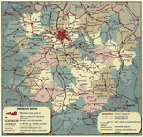
The Kharkiv region is situated in the North-East of Ukraine. It
borders Belgorod region of Russia in the North and North-East, Lugansk
region in the East, Donetsk region in the South-East, Dnipropetrovsk region
in the South-West, Poltava and Sumy regions in the West and North-West.
The territory of Kharkiv region is 31,400 square kilometers.
The extension from North to South is 210 km, from East to West - 220 km. The Don river basin accounts for 75% of the region's water
resources. The main water-way - the Seversky Donets river- is the right
hand tributary of the Don river. The total length of 867 rivers is 6,400
km and there are 156 rivers that exceed 10 km in length. There
are also some lakes in the region, the biggest one called Liman. About
50 artificial bodies of water were created in the Kharkiv region in the XX century,
the biggest ones are Krasnooskolskoye (Chervonooskolske), Pechenezhskoye (Pechenizke), Krasnopavlovskoye (Chervonopavlivske).
The Northern part of Dnipro-Donbass water canal runs through the territory
of the region. The Kharkiv region is divided into 26 districts while there are 16 towns, 62 urban-type settlements , 1861 villages and farm-steads (khutors) on its territory. The biggest towns are Kharkiv with the population of 1,600,000 people, Izyum, and Lozova. Other important towns are Kupyansk, Chuhuyiv, Balakliya, Bohodukhiv, Zmiyiv. The population of Kharkiv region is about 3,170,000 people. 78.8% of the population lives in towns. The average density of population is 100 people per square kilometer. The region has relatively high level of economic development.
One of the major reasons for this is its favorable geographical location.
Proximity to coal and metal resources of Donbas and Trans-Dnipro region
contributed to the development of mechanical engineering and metal working
industries. The vicinity of Russia, its Black Earth belt region, its South-West
and Southern regions predetermined the development of agriculture
in the Kharkiv region. An important factor was also the presence of its own
raw materials resources. This contributed to the development of fuel industry
and power engineering, chemical and petrochemical industry, glass and
porcelain, faience production, and the industry of construction materials. The Kharkiv region agriculture is specialized in grain, sugar beet, sunflower, meat, milk, vegetables, and fruit production. A large selection centre "Ukrainka" is known as the R&D centre of agricultural science. Kharkov region has a good transport network, 60% of which is railway. The total railway length comes up to 1442 km! Kharkiv railway junctions serve 10,000,000 passengers a year. The automobile transport though outstrips the railway in the amount of passenger traffic: buses serve almost 12,000,000 people a year. The major highways and freeways going through the region are Kharkiv - Moscow, Kharkiv - Simferopol, Kharkiv - Rostov-on-Don, and Kharkiv - Poltava. There are 16 intra-regional, 68 inner regional and 342 district roads. The total length of motorways is 15,000 kilometers. The Kharkiv airport used to have 200 flights a day, almost all of them were passenger flights |
 |
Welcome Greeting |
About Kharkiv |
Official Kharkiv |
Industry |
Business & Law Science & Education | Culture & Arts | Tourism & Leisure | City & Region | What, When, Where | Internet |